
Historic Core
The village of Sharlston, as depicted on mid-19th century mapping, was a green-side settlement running for around 330m on the north and south side of Sharlston Green. The Green widened at its eastern end on to Sharlston Common which still remains un-enclosed.
It is likely that Sharslton originated as a medieval village. “Scharueston” was first recorded in 1173-93 and at several other times in the later medieval period. (Smith, A.H. 1961. Part ll. P.114). Although the form could be classed as a village green settlement, settlement on the southern side of the green is more linear in form with rear toft plots and a back lane which is suggestive of a post Conquest planned settlement. There was a large area of enclosed strip fields depicted on mid-19th century mapping occurring most clearly to the north, east and south of the village. The field to the south merged with those associated with the nearby villages of Foulby and Crofton.

The village contains several listed features. One is a farm house to the north of the green with 17th century origins (Images of England UID 437093). The others are estate features relating to Sharlston Hall. Sharlston Hall is a sprawling elite residence which developed from the 15th century as a timber framed hall house with 16th and 17th century additions. The hall has Grade ll* Listed building status. The entrance gateway to the hall, forecourt wall and gate posts 10 metres south of the hall, gazebo & boundary wall of the garden to the west of the hall and The Dovecote on Lidget Lane.
Modern OS mapping (2015 Master Map) still depict five farms scattered around Sharlston Green. There has been some 20th century residential development ( Harvest Meadows and The Heathers) but this is small scale and piecemeal and Sharlston remains village-like.
Industrial Period Development
The village had a smithy and Sharlston Windmill (corn) was depicted in fields to the south of the hall. A reservoir was also depicted on the southern side of the common in c.1850, though the association is unclear. Sharlston Common is a Scheduled Ancient Monument (SAM 30962, WYHER PRN 3831). It was an area of common that was subject to coal and ironstone extraction from the medieval period through to the 17th century which is confirmed by documentary evidence. The monuments are clearly visible and include bell pits and other earthworks associated with coal and ironstone mining.
Mid-19th century OS mapping depicts two coal pits at the eastern end of Sharlston village which suggest small scale extraction continuing into the Industrial Period. The mining had changed by the end of the 19th century with the small pits abandoned in favour of large scale collieries.
There are four large scale collieries within 3km of Sharlston:
- New Sharlston Colliery. 1.6km northwest of Sharlston. Sharlston Colliery opened in 1858 and closed in July 1993. This area is now agricultural land.
- Victoria Colliery. 1.7km northeast of Sharlston. Formerly the Snydale Colliery. Opened in 1861 and closed in 1965. 1.7km northeast of Sharlston. Site reverted to fields.
- Nostell Colliery. 1.9km south of Sharlston. Opened in 1854 and operated through to 1987. Land remains derelict.
- Sharlston West Colliery (also known as the Walton Colliery). 3.1km west of Sharlston. Operated between 1890 and 1979. Area reclaimed as the Walton Colliery Nature Park.
There were large scale collieries all established in the mid to late 19th century, all with onsite processing and all had direct access to national railway routes. New Sharlston Colliery and Victoria Colliery probably had the most relevance to Sharlston.
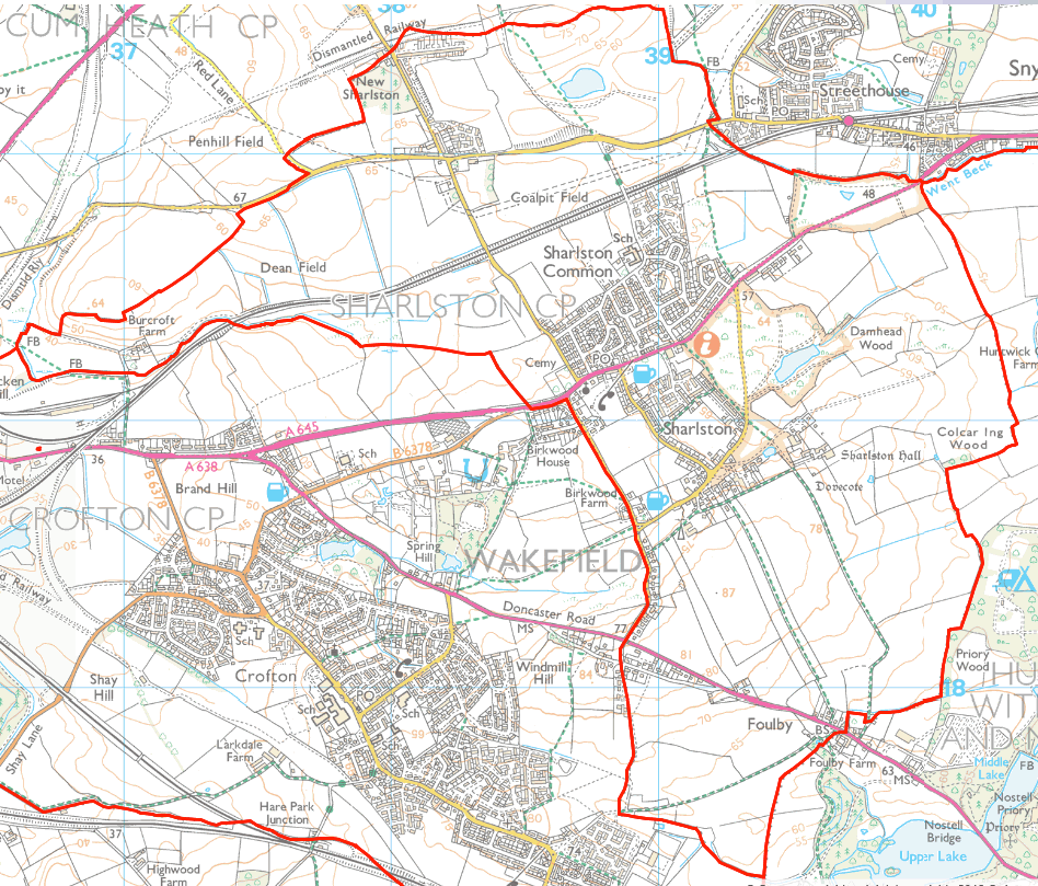
A new village formed 500m to the north of Sharlston. Sharlston Common (Village) was first named on late 19th century OS mapping and consisted of rows of terraced houses running perpendicular to the east west route of Weeland Road. A few Industrial Period Houses were also present on Grime Lane. The settlement also gained the Sharlston Hotel (pub), the Church of St Luke and the Jubilee Recreation Ground. Development continued on a small scale into the early 20th century with further houses occurring as ribbon development along Weeland Road and Grime Lane. The settlement also gained a large area of allotments to the north of the village. A few terraces were also constructed closer to New Sharlston Colliery. The village was relatively small scale compared to other Wakefield Industrial settlements. Old Sharlston appeared largely unaffected.
20th Century and Beyond
Two small estates were added in the early 20th century at the western end of the village, comprising development around Northfield Road, Jubilee Road and Birkwood Avenue. Development began in the 1930s and was completed in the early post-war period probably as social housing provision for mining families. Piecemeal ribbon development also occurred on Weeland Road, particularly to the east of the village. Sharlston Community School also originates from the interwar period and this is located on the northern side of the village.
The largest post-war development occurred to the north of Weeland Road, the Woodside Estate was built in the 1950s as social housing on previously undeveloped land. Birkwood Avenue was a smaller estate of similar date built to the west of Sharlston Common.
There have been two significant post-war developments: Beechfield Drive is a late 20th century 3 hectare development built to the north of Sharlston Green and The Heathers, of similar scale and date is to the south. Both occur as new builds on former agricultural land.
Source of Information: Historic England. Wakefield Historic Landscape Characterisation Project January 2017. Settlement Analysis Volume 1, Part 4 Wakefield Library.
New Sharlston
New Sharlston is a small settlement, consisting of Long Row, Crossley Street and High Street. Crossley Street was named after the principal Sharlston Colliery Company shareholders, John Crossley and Sons Ltd, carpet manufacturers of Halifax (Taylor, 1976)
Terraces of over 150 back-to-back houses were built from 1864 onwards by the New Sharslton Colliery Company to house their workers, designed by John Gomersall. A Methodist Chapel built in 1868 for the community needs was followed by the erection of a day school in 1869, both on Crossley Street
The design was trusted to the same architect of the colliery buildings, the construction of each house costing the company just over £100 (Taylor, 1976). The original water supply (1870s) came from the neaby Sharlston Dam on the common (Thompson, 1989)
When the properties’ ownership passed over to the National Coal Board after Nationalisation, local authority grants were used for the interior modernisation of the houses. In 1961 twenty-eight back- to-backs at the upper end of Long Row were converted into fourteen through houses
In the 1970s the houses were offered to existing tenants so that today a great percentage is privately owned (Taylor, 1976). This is one of the few remaining colliery communities, although both the school and the chapel have been demolished
In 1982 Lucy Caffyn, visited No. 3 Long Row to record it as part of the RCHME’s Workers Houses Survey. A copy of her description notes, drawn plans, and photographs are on file in the HER.
Source of information: West Yorkshire Archaeology Advisory Service (WYAAS)